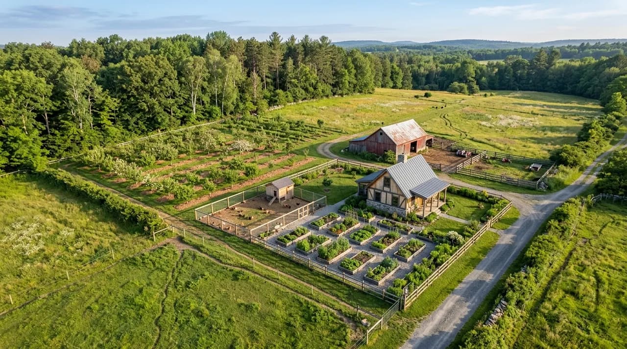
Permaculture site planning relies on two complementary spatial frameworks: zone analysis, which organizes landscape elements according to human visitation frequency, and sector analysis, which maps wild external energies moving across the property. Together, these frameworks determine where physical structures, water storage, and living plantings belong to minimize wasted physical effort and harvest natural environmental flows. Unlike vertical canopy stratification, which categorizes plants by physical height from ground cover to overstory, zone-and-sector planning dictates the horizontal layout and functional efficiency of the entire landscape.
The zone planning concept: organizing by visitation frequency
The concept of zones in permaculture design originates from a simple ergonomic observation: elements placed far from the central dwelling receive less observation, sporadic maintenance, and inconsistent harvesting. Zones are numbered from zero to five, representing a gradient of human activity radiating outward from the primary living space.
Zones are not abstract, concentric circles drawn with a drafting compass. In reality, terrain, prevailing paths, microclimates, and existing vegetation distort their boundaries. A steep rocky slope twenty meters from the back door may function ecologically as Zone 4 or 5 because steep topography discourages routine foot travel, while a flat path leading to an access gate fifty meters away may function as Zone 1.
The six zones fulfill distinct operational functions:
- Zone 0: The emotional and operational core of the system. This includes the home, farmhouse, barn, or outdoor kitchen where people live, cook, process food, and plan tasks.
- Zone 1: The immediate doorstep environment visited multiple times each day. It contains culinary herbs, quick-turnaround salad greens, worm bins, seedling propagation benches, outdoor wash stations, and rainwater controls.
- Zone 2: Semi-intensive production areas visited once or twice daily. This zone accommodates main vegetable garden beds, small poultry flocks requiring regular egg collection and feeding, soft fruit brambles, compost windrows, and juvenile perennial nursery beds.
- Zone 3: Broadscale production visited weekly or seasonally. This includes staple field crops, commercial orchards, main livestock pastures, multi-row windbreaks, and farm-scale irrigation reservoirs.
- Zone 4: The semi-wild managed landscape managed through low-input intervention. It encompasses woodlots for firewood and construction timber, seasonal nut orchards, coppice stands, and low-density silvopasture.
- Zone 5: Unmanaged natural wilderness. In Zone 5, humans are passive observers instead of managers. It is a wildlife sanctuary, watershed preserve, and an ecological reference point for observing how native plant communities solve local environmental challenges without irrigation or imported fertility.
Detailed spatial variations across different land sizes are explored further in our guide to permaculture zones.
Distinguishing spatial zones from canopy layers
Growers new to ecological agriculture frequently confuse spatial zones with food forest layers. The distinction is fundamental to sound site layout. Zones describe horizontal placement across the landscape relative to human access, whereas canopy layers describe vertical stratification within a specific plant community.
A single multi-layered planting guild (incorporating a fruit tree canopy, nitrogen-fixing sub-canopy shrub, herbaceous nutrient accumulators, deep taproots, and fungal ground covers) can be situated within any zone. For example, a dwarf fruit tree guild containing chives, strawberries, and comfrey may sit three steps from the kitchen door in Zone 1, where the grower picks fresh leaves daily. Conversely, an identical ecological guild built with standard-sized rootstocks might be installed eighty meters away in Zone 3, where it is a low-maintenance, self-mulching cropping system visited primarily during autumn harvest. Zones dictate how much labor you will invest in an area; canopy layers dictate how plants share light and soil volume within that area.
Sector analysis: mapping external energies
While zones reflect internal energy originating from the grower, sector analysis maps external energies originating from beyond the boundary lines. These environmental forces (including sunlight, wind, wild water flow, wildfire risk, and animal vectors) cross the site continuously. The designer cannot stop them from occurring, but can position landscape elements to harvest their benefits or deflect their hazards.
A comprehensive sector analysis identifies several primary energy channels:
- Solar sector: The path of the sun across summer and winter horizons. Siting greenhouses, solar arrays, and high-light crops requires mapping summer sun elevation to prevent overheating while capturing low-angle winter radiation.
- Wind sector: Prevailing wind directions often shift between seasons. Gentle summer breezes provide passive cooling and ventilation, whereas freezing winter gale sectors dry out soil, desiccate evergreen foliage, and damage delicate fruit blossom.
- Water and run-on sector: The trajectory of storm runoff entering the land from uphill neighbors or road surfaces. Mapping this sector allows a grower to intercept clean surface water into swales or divert sediment-laden road runoff away from vegetable beds.
- Wildfire sector: High-risk approach vectors determined by dry seasonal winds and surrounding combustible brush. Placing inflammable barriers, green firebreaks, and emergency water storages along this sector forms a defensive shield for structures.
- Wildlife and livestock vector: Entry corridors used by deer, wild boar, or grazing animals. Understanding these travel lines dictates where to install secure perimeter fencing or plant unpalatable thorny nurse hedgerows.
By overlaying sector wedges onto a site base map, designers identify where zones and sectors intersect. For instance, placing a dense evergreen shelterbelt in Zone 4 along the winter wind sector protects Zone 1 vegetable beds and the Zone 0 dwelling from cold drafts, substantially lowering indoor heating demands.
Worked example: laying out a quarter-acre suburban lot
To demonstrate how zones and sectors interact on real land, consider a typical quarter-acre suburban property measuring approximately 1,000 square meters. The parcel features a single-family house positioned near the northern road frontage, a gently sloping south-facing backyard, prevailing desiccating winds arriving from the west, and periodic storm runoff entering the rear fence line from an uphill adjacent property.
Applying permaculture planning transforms this suburban block into an integrated production system:
- Zone 0 (The House): The existing residence is the central hub. Kitchen food preparation opens onto the back patio, establishing the primary departure point for daily homestead chores.
- Zone 1 (Backyard Patio Perimeter): Raised timber beds are constructed along the patio steps, positioned for immediate access. These beds house culinary mint, parsley, loose-leaf lettuces, and scallions. A stackable worm vermicompost bin sits along the shaded eastern exterior wall, receiving fresh kitchen scraps daily without odor. Two 1,000-liter rainwater totes capture water from downspouts to supply the adjacent seed-starting bench.
- Zone 2 (Central Backyard): Beyond the patio, a set of six intensive annual vegetable beds is arranged across the sunny southern exposure. A compact chicken coop housing four laying hens is built along the eastern fence; the morning walk to collect eggs and deposit garden weeds aligns with the daily vegetable watering route. Surrounding the chicken run, hardy cane berries and dwarf gooseberries benefit from nutrient-rich runoff during heavy rains.
- Zone 3 (Lower Backyard Section): Because a quarter-acre property lacks acreage for broadscale grazing or commercial grain crops, Zone 3 is adapted as a compact orchard. Four semi-dwarf fruit trees (two apples, a European pear, and an Asian plum) are spaced across the lower lawn, underplanted with daffodil bulbs for rodent deterrence and Dutch white clover for soil nitrogen.
- Zone 4 (Western and Southern Perimeter): Along the western boundary, a multi-species windbreak is planted to intercept dry winds. Hardy shrubs such as hazelnut, elderberry, and seabuckthorn are interplanted to create a dense hedge that filters wind turbulence while producing annual harvests of nuts and berries for craft use and poultry supplement.
- Zone 5 (The Rear Drainage Corner): The lowest corner where uphill runoff naturally settles is fenced off from domestic activity and left wild. Native wetland grasses, dogwood shrubs, and willow cuttings are allowed to grow untouched. This undisturbed pocket absorbs excess storm water, prevents downstream erosion, and provides breeding habitat for ground beetles, toads, and songbirds that forage on garden slugs in Zones 1 and 2.
Practical planning guidelines for working properties
Successful site layout requires regular adjustment as seasons progress and observations deepen. Designers avoid several common mistakes by adhering to practical field guidelines:
First, never plan a site solely on paper during a single dry afternoon. Sector energies fluctuate dramatically across seasons; a site that seems dry and sheltered in midsummer may turn into a windswept bog during late winter storms. Spending time observing surface water flow during heavy rainfall reveals authentic drainage lines that topographic maps often conceal.
Second, resist the urge to disperse high-maintenance elements across distant zones. Installing a delicate vegetable garden or seedling nursery fifty meters from the house almost always leads to irregular watering and undetected pest damage. Keep what requires daily observation as close to your daily path of movement as possible.
Third, acknowledge personal limitations and scale production incrementally. Beginning with an intensive, well-managed Zone 1 creates confidence and immediate kitchen returns. Expanding into peripheral zones becomes sustainable only after the core living zone operates smoothly within the grower's available time.