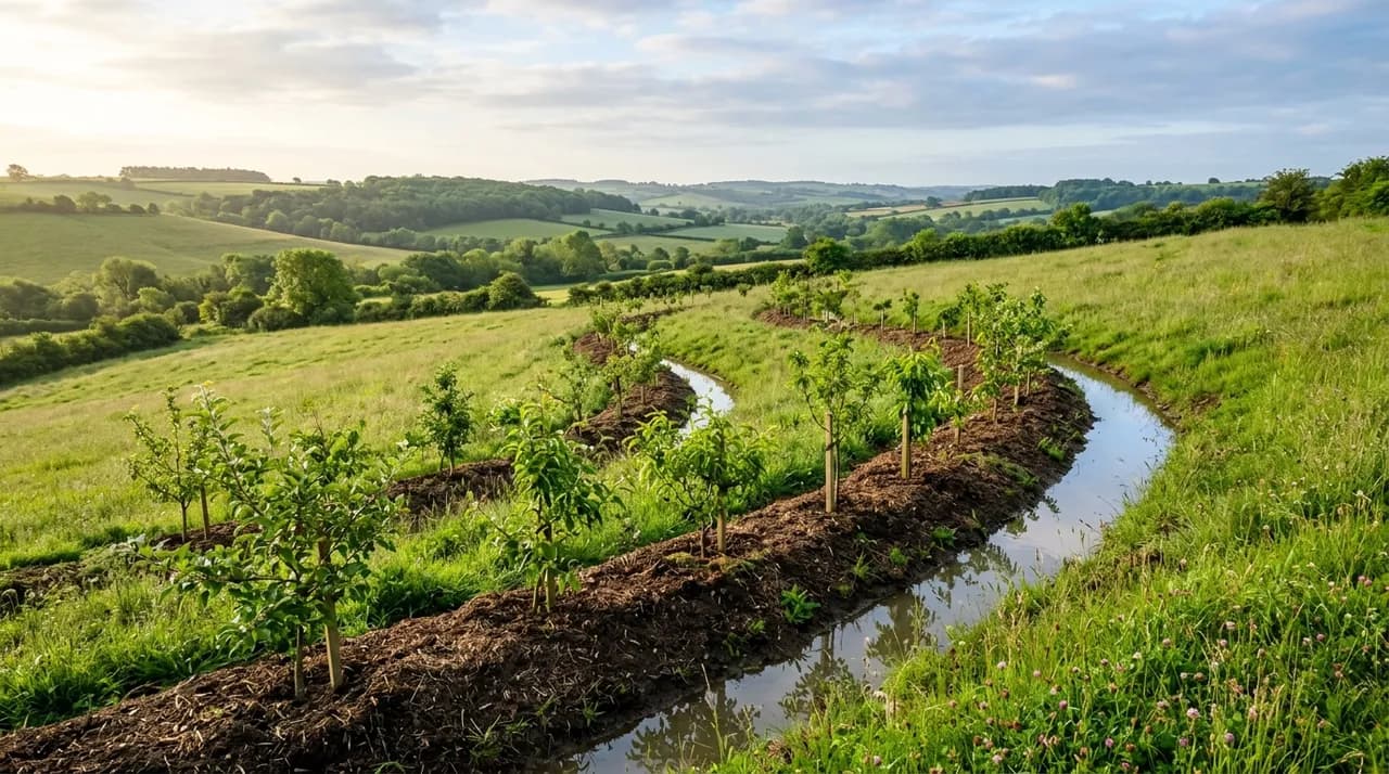
Keyline design and contour swales are passive water-harvesting techniques engineered to intercept, slow, and infiltrate surface rainfall runoff before it erodes downhill slopes. While contour swales follow dead-level elevation lines to pool surface runoff and recharge the underlying soil moisture lens, keyline design employs subtle off-contour cultivation patterns to guide moisture out of saturated valleys and distribute it across dry ridges. Neither technique is a drainage ditch, and neither produces meaningful benefits on completely flat topography or excessively permeable, deep sandy soils where surface runoff never develops.
Reading the slope: contours, ridges, and valley forms
Effective water harvesting begins with careful observation of slope morphology. When precipitation falls on a hillside faster than the soil can absorb it, excess water forms sheet wash that flows downhill perpendicular to the land's contour lines. As this surface water moves, topography naturally dictates its behavior:
- Ridges (interfluves): Convex landforms that shed water outward in divergent directions. Because water constantly runs away from ridge crests, soils here tend to be shallow, drier, and prone to wind exposure.
- Valleys (drainage channels): Concave landforms that gather runoff into convergent streams. Valleys naturally accumulate topsoil and moisture, but during heavy storms, concentrated water velocity can rapidly scour gullies and erode fertile bottomland.
In the 1950s, Australian agricultural engineer P.A. Yeomans observed that hillsides exhibit an inflection point where the slope profile shifts from convex (shedding) to concave (accumulating). Yeomans termed this transition the "keypoint." A contour line surveyed through this point is known as the "Keyline."
Understanding the relationship between ridges, valleys, and contours allows land managers to alter how water travels across a property. Rather than allowing rainfall to rush into eroding gullies, thoughtful earthworks intercept that energy and distribute moisture across the drier ribs of the landscape.
What a swale actually does on the landscape
In permaculture design, a swale is an uncompacted trench excavated precisely along a dead-level contour line, with the excavated earth placed on the downhill side to form a soft, mounded berm.
When heavy rainfall generates overland runoff, the swale basin intercepts the moving sheet flow. Because the trench is perfectly level, the collected water ceases its downhill momentum and spreads evenly along the entire length of the trench rather than concentrating at one low point. The swale operates through three sequential hydrological mechanisms:
- Slowing runoff: Halting the velocity of surface water eliminates its capacity to carry away detached soil particles, trapping eroded silt and organic debris inside the trench.
- Sinking moisture: As water stands in the trench, hydrostatic pressure forces moisture downward and outward into the subsoil, creating a subterranean "water lens" or localized underground reservoir.
- Supporting perennial vegetation: The uncompacted downhill berm provides a loose, aerated planting zone. Deep-rooting fruit trees, support shrubs, and perennial ground covers planted on the mound draw directly from the hydrating plume beneath them without having their roots submerged in standing water.
Over successive seasons, repeated infiltration beneath swale systems can elevate localized groundwater tables and extend stream flow further into dry seasons.
What a swale does not do: operational limitations
Swales have been widely promoted in ecological literature, leading some growers to install them where they are ineffective or hazardous. Successful installation requires understanding what swales cannot do:
First, a swale is not a drainage ditch. Drainage ditches are dug with a continuous downward slope, typically a gentle gradient, to evacuate excess water quickly away from buildings or waterlogged crops. In contrast, a swale has zero gradient. Digging a swale in saturated, poorly draining clay soils where surface water already ponds for weeks will not drain the site; it simply creates a stagnant, anaerobic trench that damages nearby crops.
Second, swales fail on flat ground. On landscapes with less than a one or two percent slope, rainfall rarely generates significant sheet runoff. Without moving overland flow to intercept, an excavated trench catches only the rain falling directly into its opening. On level plains, shallow retention basins, mulched beds, or keyhole gardens capture precipitation far more effectively without the labor of linear trenching.
Third, swales do not work in deep sand. Coarse sandy soils possess exceptionally high infiltration rates; rainfall percolates almost instantly into the ground, leaving no surface runoff to catch. Furthermore, uncompacted sandy berms lack structural cohesion and collapse under heavy foot traffic or heavy rain.
Fourth, swales present severe structural hazards on steep or geologically unstable slopes. On hillsides exceeding fifteen to eighteen degrees, concentrating large volumes of infiltrated water into the subsoil can saturate subterranean slip planes, triggering soil liquefaction and catastrophic mudslides.
Finally, a swale cannot function safely without an engineered spillway. During extreme, once-in-a-decade rainfall events, swales inevitably fill to capacity. If water overflows randomly over an unarmored earthen berm, it cuts a narrow breach that rapidly erodes the mound, releasing a sudden torrent that washes out downslope beds. Every swale requires a wide, level, heavily grassed sill spillway excavated into solid undisturbed soil at one or both ends, slightly lower than the berm crest, to release surplus water gently into safe overflow pathways.
Keyline design vs. contour swales: different tools for different scales
While permaculture swales follow exact contours to hold water stationary, Yeomans' Keyline system uses specialized cultivation techniques on broad acreage to move water dynamically across the land.
Keyline patterning relies on a non-inversion subsoil plow (the Yeomans plow) which fractures compacted subterranean hardpans without turning over the soil or burying topsoil. Plowing lines are surveyed not on contour, but at a gentle, deliberate fall away from valley centers toward the dry crests of adjacent ridges.
During heavy rainfall, water entering the ripped subsoil furrows moves gradually outward toward the dry ridges. By redistributing runoff from naturally wet pockets to dry knolls, Keyline cultivation balances soil moisture across large pastures, increases biological root depth, and accelerates topsoil formation without constructing massive earthen berms.
On working farms, Keyline patterns provide the geometrical foundation for agroforestry systems such as alley cropping and diversified types of agroforestry. Tree rows planted along Keyline contours divide open pastures into manageable alleys where machinery can travel parallel to cultivation lines, combining hydrological management with commercial timber, forage, or orchard crops.
Siting and constructing a contour swale
Installing an effective swale on a smallholding or garden requires systematic field preparation:
- Survey the contour: Walk the slope using an A-frame level, water level, or optical transit. Drive wooden stakes every three to five meters along the contour line. Adjust any stakes that deviate from dead level; even a slight slope will cause water to pool at the lower end and overtop the berm.
- Determine basin dimensions: For small gardens, a trench forty to sixty centimeters wide and thirty centimeters deep is usually sufficient. On larger rural properties, swale basins can measure one to two meters across.
- Excavate and mound: Dig the trench, piling all loose topsoil and subsoil onto the downhill side of the stakes. Form the mound into a broad, gently rounded berm rather than a steep pyramid.
- Level the trench bottom: Ensure the base of the trench remains flat and uncompacted so water spreads evenly rather than collecting in deep spots.
- Cut the spillway: Identify a safe overflow exit into a vegetated drainage swale, pond, or pasture. Cut a level sill into the undisturbed earth at the chosen end of the swale, ensuring it sits at least ten centimeters below the lowest point of the berm crest.
- Plant immediately: Unprotected earth erodes quickly in rain. Cover the berm with deep straw or woodchip mulch, seed it immediately with clover and grass, and plant perennial species to stabilize the soil with living root networks, integrating the feature into your broader food forest design.
When properly matched to slope, soil texture, and rainfall intensity, swales and keyline patterns convert destructive stormwater into stable subterranean hydration.